Now, on the the report!
 Start: Grand Lodge. Departure at 6am. Riders should arrive early enough to get checked in, drop your (small, please!) overnight bag with the me or Susan France, and be ready for pre-ride announcements at 5:55.
Mile 10: The Banks-Vernonia Trail is now 100% paved! This resulted in several route changes this year. Riders will now enter the trail at the newly built trailhead in Banks. Water and restrooms available. Riders will STAY ON THE TRAIL for it’s entire length to Vernonia. Do not exit the trail at Stubb Stewart like last year. (BTW – there’s a LOT of wildlife on the trail. In addition to startling scores of birds and a surprising number of rabbits, I also nearly crapped my pants when a HUGE coyote leaped out of the underbrush just to my left, dashed across the trail, and then crashed into the underbrush on the other side. Um yeah, I was wide awake after that!)
 Mile 23: New info control on the Banks Vernonia Trail.
Mile 46: I got a flat tire here. This matters not a whit to you, but sucked for me.
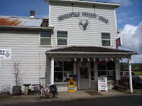 Mile 53: Birkenfeld Store – This is not a control, but stop if you are cold, hungry or need a break. I let the proprietor know the group is coming through. He promised to put on a large kettle of soup. Might be baked potato soup, which I can tell you from first hand experience is quite yummy.
Tank up – you’ve got a big hill to climb over the coast range!
Mile 107: Take note: The info control location has changed, which shortened the long flat, sucky, headwindy stretch heading north at Ft. Stevens. You’re welcome.
From here, the route is mostly flat until after Seaside. Shoulder is in good shape and mostly swept clean. There’s a ton of traffic on 101 on the weekend, though, so be vigilant. This will be the most heavily trafficked stretch of road the entire weekend.
 Tank up – it’s gonna get hilly. Three big hills to climb between Seaside and Nehalem. If you’re hungry, Angelina’s in Seaside (on the right in a little strip mall before the Pizza Hut) has tasty panini. I recommend the Chicken Parm.

Mile 196: Pacific City. Last services until Lincoln City. For a fast control, I recommend going to mile 197 (the intersection @ Brooten) and going to the Shell Station.
The 3 mile stretch of road leaving Pacific City is in moderately poor shape. I got a flat on this stretch on the March 300K thanks to a pothole.
Tank up – Slab Creek Rd stands between you and sleep.
Mile 208: Slab Creek Rd. A mile or so BEFORE this, you’ll see a road on the left called North (N.) Slab Creek. Don’t take it. (Trust me, I made this mistake last year in the dark, and it sucked.) It’s in terrible, terrible shape, parallels 101 for about a mile or so, then dumps you back onto 101. Then just beyond that is the entrance to Slab Creek Rd. That’s the one you want. Slab Creek Road is in poor shape in some places. Lots of cracked pavement and some good-sized potholes. This is particularly true in the first couple of miles. Might not be so bad for those of you fast enough to get there in the daylight, but in the dark (and it’s VERY dark – after the 1st couple miles there are no houses and no street lights) it felt like I had to maneuver around quite a few tire-eating holes. Slab Creek climbs 6 miles to the info control, then climbs some more after that before finally descending. The descent is twisty and steep and most of you will be doing it in the dark. I was happy to have both my generator light and a helmet light that I could use to look ahead into the turns. Fortunately the pavement on the descent is in better shape, but still, please use caution.
Mile 222: Lincoln City I’ll be in room 114, which is immediately off the lobby on the left hand side. I’ll have your drop bags, and some snacks and drinks. If you are very hungry, though, you may wish to hit up the Safeway or the 24hr Shell Station, both on the right side of 101, just before the Motel 6. The Motel 6 does not serve breakfast, and at the hour in which most of you will be departing, there isn’t any place open to get breakfast (I left at 5:30am and LC was a ghost town at that hour.). However, the rooms have a microwave and a fridge, so you can buy food and make your own breakfast.
Please respect the other hotel guests by keeping quiet in the hallways. And, if it’s raining, which it looks like it may be, please be respectful of the carpets and the linens. We would like to be able to use this hotel again in the future.
Please drop off your overnight bag with me no later than 6am on Sunday morning (the control closes at 5:48). I’d like to be able to get a few hours sleep before making the drive back to Portland. If you DNF at this point, please do not look to me for a ride home. My vehicle will be filled with overnight bags and can not accommodate bicycles.
 DAY TWO:
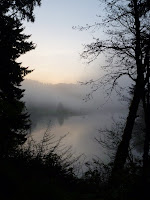
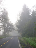
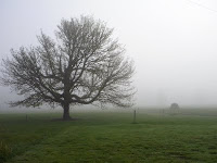
I’ll just come right out and say it. I think Day 2 is really challenging, more challenging than the route profile makes it appear. (But maybe I’m just out of shape!) Particularly from Lincoln City to Blodgett, this course will throw a lot of curve balls your way. It’s likely to be either very cold or very wet (last year we had the extra bonus of getting both. This year it was just very cold and foggy for my pre-ride. But rain is in the forecast…). The terrain is surprisingly hilly, including a real doozy of a climb between Nashville and Summit. And there’s a nice gravel section thrown in for good measure. On the bright side, the route is stunningly pretty, and there’s virtually zero traffic all the way to Blodgett.
 Mile 252: Siletz. Your first opportunity for services since LC. The café is reportedly open at 5am. When I went through around 8am, the OPEN sign was lit, but the café looked dark. I did not investigate further, as I didn’t need anything at that point. The grocery is open at 7am.
 Miles 260: Logsden store. Opens at 8am. I let them know you are coming. OVERNIGHT RIDERS: Answer the info control in lieu of getting a signature.
 Mile 270: Two miles of gravel. The ascent is less than a mile and the surface has a lot of hardpacked areas. It was dry this weekend, so it wasn’t a tough climb. Could be slick in the rain. USE CAUTION on the descent. There’s a lot of loose gravel, some washboarding and potholes. It’s also fairly twisty. There’s no guardrails or edge of road markings, so overnight riders will want to be especially cautious.
Miles 274: The old Nashville store is now a food bank. They open at 11am. They won’t sell you anything, but if you need water, a rest room or snacks, they are happy to provide. A small donation would be appreciated.
 Put your climbing legs on, there’s a steep climb on the way to Summit. Don’t let the bridge troll get you on the way up. Oh, and word to the wise: Summit is a lousy name for the town….
Mile 282: Blodgett. Store opens at 9am. OVERNIGHT RIDERS: Answer the info control in lieu of getting a signature. Everyone else: stock up on fluids and food because there’s not much of anything after this until Dallas 30+ miles later.
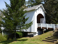 28 miles on Kings Valley Highway – it’s hilly and I hope you don’t have the soul-sucking headwinds I had for most of the length. If you find yourself needing a break, especially if it’s raining, the Ritner Covered Bridge would probably be a nice spot to get out of the rain for a few minutes.
Mile 315: Dallas. This is an open control, and you have tons of options here. I used the Subway (on the right after making the turn at Jefferson) as my control because I find the Safeway just beyond it to be a bit of a time suck. The Safeway, however, has a nice deli and several hot soup options, which I was very grateful for last year when it rained a lot on this brevet.
Mile 348: Dayton You’ll want to use the market at the end of the Webfoot Rd leg as your control. There’s not much else in Dayton, but the market is reasonably well stocked. OVERNIGHT RIDERS: The market is CLOSED from 2am to 7am. If you arrive during these hours, please go 5 blocks off route to the US Bank on 3rd Street and get a receipt from the 24 hr ATM machine there.
 Mile 350: Lafayette Last services before the finish.
Mile 373: Grand Lodge at Forest Grove. Susan and/or Susan will likely be in the small meeting room at the top left of the stairs from the parking lot. If you bring a towel and $5, you can get a key to the showers and the outdoor soaking tub. Highly recommended!
 Mile 23: New info control on the Banks Vernonia Trail.
Mile 46: I got a flat tire here. This matters not a whit to you, but sucked for me.
 Mile 53: Birkenfeld Store – This is not a control, but stop if you are cold, hungry or need a break. I let the proprietor know the group is coming through. He promised to put on a large kettle of soup. Might be baked potato soup, which I can tell you from first hand experience is quite yummy.
Tank up – you’ve got a big hill to climb over the coast range!
Mile 107: Take note: The info control location has changed, which shortened the long flat, sucky, headwindy stretch heading north at Ft. Stevens. You’re welcome.
From here, the route is mostly flat until after Seaside. Shoulder is in good shape and mostly swept clean. There’s a ton of traffic on 101 on the weekend, though, so be vigilant. This will be the most heavily trafficked stretch of road the entire weekend.
 Tank up – it’s gonna get hilly. Three big hills to climb between Seaside and Nehalem. If you’re hungry, Angelina’s in Seaside (on the right in a little strip mall before the Pizza Hut) has tasty panini. I recommend the Chicken Parm.
Mile 196: Pacific City. Last services until Lincoln City. For a fast control, I recommend going to mile 197 (the intersection @ Brooten) and going to the Shell Station.
The 3 mile stretch of road leaving Pacific City is in moderately poor shape. I got a flat on this stretch on the March 300K thanks to a pothole.
Tank up – Slab Creek Rd stands between you and sleep.
Mile 208: Slab Creek Rd. A mile or so BEFORE this, you’ll see a road on the left called North (N.) Slab Creek. Don’t take it. (Trust me, I made this mistake last year in the dark, and it sucked.) It’s in terrible, terrible shape, parallels 101 for about a mile or so, then dumps you back onto 101. Then just beyond that is the entrance to Slab Creek Rd. That’s the one you want. Slab Creek Road is in poor shape in some places. Lots of cracked pavement and some good-sized potholes. This is particularly true in the first couple of miles. Might not be so bad for those of you fast enough to get there in the daylight, but in the dark (and it’s VERY dark – after the 1st couple miles there are no houses and no street lights) it felt like I had to maneuver around quite a few tire-eating holes. Slab Creek climbs 6 miles to the info control, then climbs some more after that before finally descending. The descent is twisty and steep and most of you will be doing it in the dark. I was happy to have both my generator light and a helmet light that I could use to look ahead into the turns. Fortunately the pavement on the descent is in better shape, but still, please use caution.
Mile 222: Lincoln City I’ll be in room 114, which is immediately off the lobby on the left hand side. I’ll have your drop bags, and some snacks and drinks. If you are very hungry, though, you may wish to hit up the Safeway or the 24hr Shell Station, both on the right side of 101, just before the Motel 6. The Motel 6 does not serve breakfast, and at the hour in which most of you will be departing, there isn’t any place open to get breakfast (I left at 5:30am and LC was a ghost town at that hour.). However, the rooms have a microwave and a fridge, so you can buy food and make your own breakfast.
Please respect the other hotel guests by keeping quiet in the hallways. And, if it’s raining, which it looks like it may be, please be respectful of the carpets and the linens. We would like to be able to use this hotel again in the future.
Please drop off your overnight bag with me no later than 6am on Sunday morning (the control closes at 5:48). I’d like to be able to get a few hours sleep before making the drive back to Portland. If you DNF at this point, please do not look to me for a ride home. My vehicle will be filled with overnight bags and can not accommodate bicycles.
 DAY TWO:
I’ll just come right out and say it. I think Day 2 is really challenging, more challenging than the route profile makes it appear. (But maybe I’m just out of shape!) Particularly from Lincoln City to Blodgett, this course will throw a lot of curve balls your way. It’s likely to be either very cold or very wet (last year we had the extra bonus of getting both. This year it was just very cold and foggy for my pre-ride. But rain is in the forecast…). The terrain is surprisingly hilly, including a real doozy of a climb between Nashville and Summit. And there’s a nice gravel section thrown in for good measure. On the bright side, the route is stunningly pretty, and there’s virtually zero traffic all the way to Blodgett.
 Mile 252: Siletz. Your first opportunity for services since LC. The café is reportedly open at 5am. When I went through around 8am, the OPEN sign was lit, but the café looked dark. I did not investigate further, as I didn’t need anything at that point. The grocery is open at 7am.
 Miles 260: Logsden store. Opens at 8am. I let them know you are coming. OVERNIGHT RIDERS: Answer the info control in lieu of getting a signature.
 Mile 270: Two miles of gravel. The ascent is less than a mile and the surface has a lot of hardpacked areas. It was dry this weekend, so it wasn’t a tough climb. Could be slick in the rain. USE CAUTION on the descent. There’s a lot of loose gravel, some washboarding and potholes. It’s also fairly twisty. There’s no guardrails or edge of road markings, so overnight riders will want to be especially cautious.
Miles 274: The old Nashville store is now a food bank. They open at 11am. They won’t sell you anything, but if you need water, a rest room or snacks, they are happy to provide. A small donation would be appreciated.
 Put your climbing legs on, there’s a steep climb on the way to Summit. Don’t let the bridge troll get you on the way up. Oh, and word to the wise: Summit is a lousy name for the town….
Mile 282: Blodgett. Store opens at 9am. OVERNIGHT RIDERS: Answer the info control in lieu of getting a signature. Everyone else: stock up on fluids and food because there’s not much of anything after this until Dallas 30+ miles later.
 28 miles on Kings Valley Highway – it’s hilly and I hope you don’t have the soul-sucking headwinds I had for most of the length. If you find yourself needing a break, especially if it’s raining, the Ritner Covered Bridge would probably be a nice spot to get out of the rain for a few minutes.
Mile 315: Dallas. This is an open control, and you have tons of options here. I used the Subway (on the right after making the turn at Jefferson) as my control because I find the Safeway just beyond it to be a bit of a time suck. The Safeway, however, has a nice deli and several hot soup options, which I was very grateful for last year when it rained a lot on this brevet.
Mile 348: Dayton You’ll want to use the market at the end of the Webfoot Rd leg as your control. There’s not much else in Dayton, but the market is reasonably well stocked. OVERNIGHT RIDERS: The market is CLOSED from 2am to 7am. If you arrive during these hours, please go 5 blocks off route to the US Bank on 3rd Street and get a receipt from the 24 hr ATM machine there.
 Mile 350: Lafayette Last services before the finish.
Mile 373: Grand Lodge at Forest Grove. Susan and/or Susan will likely be in the small meeting room at the top left of the stairs from the parking lot. If you bring a towel and $5, you can get a key to the showers and the outdoor soaking tub. Highly recommended!